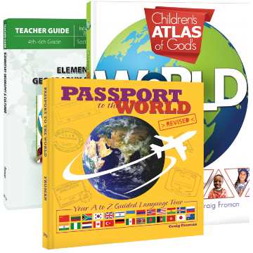
The Elementary Geography & Cultures course from Master Books consists of the Elementary Geography & Cultures Teacher Guide and two information books: Passport to the World and Children’s Atlas of God’s World. This whirlwind course takes children to selected continents and countries around the world where they learn about the people, the geography, culture, and languages.
All lesson material is drawn from the two information books. The teacher guide tells which pages to read, and when, in both books. The lessons, designed for students in grades four through six, should take about 30 to 45 minutes per day, four days per week for one school year.
Passport to the World
The first semester of the course is arranged to follow the unusual sequence as presented in Passport to the World. Languages of the selected countries are arranged in alphabetical order from A to Z. Thus, lessons begin with the study of Armenia because of its Armenian language and end with a study of Swaziland because of its Zulu language.
Passport to the World has a heavily illustrated, two-page, full-color spread on each featured country. It provides basic information in a box: the name and location of the capital city, the population, monetary unit, life expectancy, literacy rate, number of internet users, and country’s internet code. (The number of internet users should give students an idea of how widely technology is available.) Often there will be information on the spiritual status of the country’s citizens.
Children will also learn the name of one of the languages spoken there and some useful phrases in that language such as how to say “hello” and “thank you.” The selected language is not necessarily the primary language spoken in the country. For instance, while the Turkish language is introduced in conjunction with Turkey, the Cherokee language is introduced in relation to the United States.
A number of images show such things as how people dress now, their historic cultural dress, what their money looks like, cultural foods, and historical buildings or sites.
Children’s Atlas of God’s World
The second semester of the course takes students through the Children’s Atlas of God’s World. Throughout this book, geography is presented from a young-Earth, creationist viewpoint.
A number of pages are devoted to each country or continent. These pages include a number of maps and charts. These include charts with basic information for the country being studied—information such as population, area, and largest city. Maps of countries and continents have images of red pins identifying rivers, landmarks, or other geographic locations. A pin with a flag bearing a cross identifies something related to the Christian faith. Pins with green flags show the location of UNESCO World Heritage sites.
Many images are shown for each country along with explanatory information about biomes, major geographical features, historical landmarks, and sites of historical events. Some text without images relates additional information about Christian history and missionary outreach.
Teacher Guide
The Elementary Geography & Cultures Teacher Guide provides worksheets, activities, quizzes, and answer keys in addition to lesson schedules. The reproducible activity pages have pages with questions that require students to write short answers, pages with countries’ flags for students to color, and pages with recipes and food activities relating to the countries. The teacher guide also has eight quizzes as well as the answer keys for all activities and quizzes.
Summary
This Elementary Geography & Cultures course seems especially well suited for homeschooling families since the recipes and food activities are best done in a home. Children will be introduced to world geography and cultures with snippets of interesting information. You might want to add or follow up with a resource that helps students learn how to draw maps of continents and countries—a resource such as Mapping the World with Art, Drawing Around the World, or the Draw Map series.


