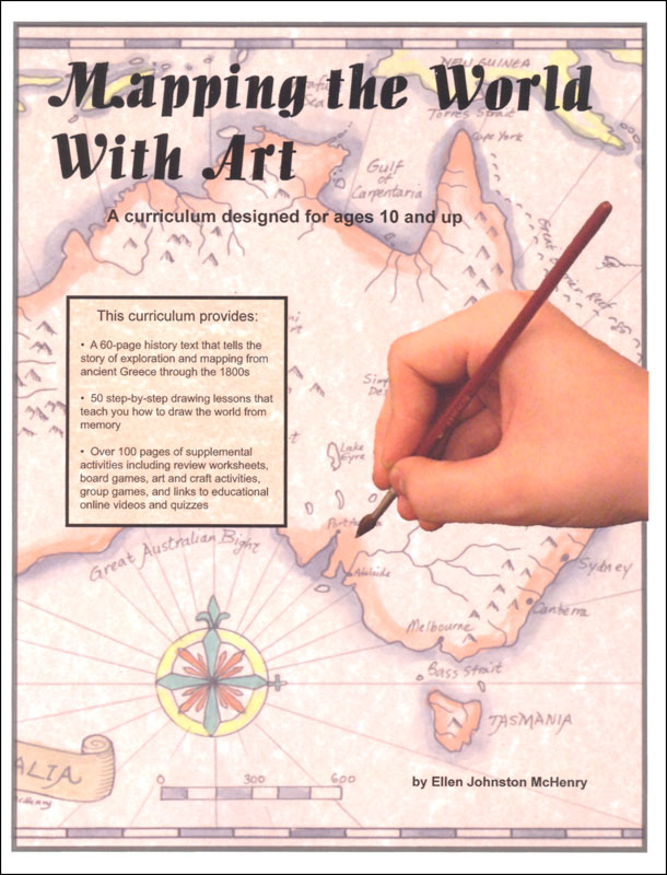
Mapping the World With Art might serve as a geography course or as a supplement to your history studies with children ages 11 and older. You can pick and choose from the activities to suit your purposes.
While the title sounds somewhat like that of another course titled Mapping the World by Heart, it is really quite different in its approach. Mapping the World by Heart provides grid paper for students to draw very detailed maps, including political boundaries. In contrast, Mapping the World With Art has students work with blank paper, teaching them to draw outline maps of continents for the most part with very few political boundaries. In some sections, Mapping the World With Art bears a little resemblance to Visualize World Geography; it occasionally uses recognizable creatures or shapes to help students visualize geographic areas. For example, the Malay Archipelago is pictured within a “”Dalmation Eagle Ray” (an imaginary variation of the Spotted Eagle Ray). Within the ray a vaguely dinosaur shaped creature is drawn to represent New Guinea, and the Spice Islands directly in front of his snout “make him sneeze.” Most drawings teach students where landforms, rivers, and other geographical features lie in relation to one another in a more straightforward manner without the “creatures.”
Students first draw regional or continental areas as they work through the lessons. Some drawings are incorporated into larger geographical areas in a subsequent lesson. A complete world map is reserved for a final project. Students really need to complete the world map rather than considering it optional. Otherwise, they are left with mastery of the parts without an understanding of how they fit together in relation to one another. Students learn about latitude and longitude lines as well as the equator, Tropic of Cancer, Tropic of Capricorn, Arctic Circle, and Antarctic Circle. By the time they are ready to tackle the final project, they will likely need no more than the templates provided in the book to assist them in general placement.
In the book, lessons show step-by-step drawings for students to follow. Drawings are accompanied by written explanations about geographic features, cities, some history, and drawing instructions. With the optional set of three DVDs, students can watch the author, Ellen McHenry, working through the drawings and providing the explanation while she works. If you use the DVDs, students should still have the book for reference as they draw.
The map drawing lessons comprise only one of three sections in Mapping the World With Art. The first section of the book is a series of illustrated lessons on the history of map making and explorations. Exploration lessons include the entire world. These lessons are interesting reading even for adults! Because the “history” lessons cover the world, those lessons are able to serve as the organizing structure for the other two sections of the book. Map drawing lessons correspond with topics in the history section. Likewise, activities in the third section also correspond to the history lessons. While it certainly makes sense to use the corresponding lessons from all three sections of the book, you need not use all of them. Also, you need not always use lessons in order. If you want to correlate lessons with core history studies using another resource, you might rearrange them for that purpose. However, you do have to watch for instances where one drawing is incorporated into another such as the early lesson where students learn to draw the Nile River while a later lesson has them draw the continent of Africa, including the Nile River.
The history lessons discuss and show various types of maps used throughout recorded history, The second and third lessons discuss work of early Greek geographers as they used astronomical observations and the changing angles of the sun's shadow on sundials to develop a better understanding of the earth's shape and to develop the idea of longitude and latitude lines. Some basic geometry is used to explain these concepts. The entire history section is written at a level most appropriate for teens rather than younger students. Younger students might be able to complete the map drawings even if the history is over their heads, but it is probably best to use the entire course together at a later date.
The third part of the book presents a number of activities correlating with each history and map lesson. You can pick and choose from among the activities rather than tackling all of them. Activities are as simple as watching You Tube video clips and as complex as creating and playing board games or constructing a star clock. Some activities like creating a compass rose are more artistic, and making and decorating maps out of cookie dough will likely appeal to everyone. Within the activity section are also some review activities: worksheets, a Pictionary style game, and a guessing game. You should try to use these even if you skip some of the others activities. Games obviously require at least two players. A few games require at least four players, making them more practical for group classes. The final project, creating a world map, is included at the end of the activities section.
The book is available in PDF or print formats. The color illustrations sometimes rely on color reproduction, so keep this in mind if you are considering printing out black and white copies from which to work. If you work with the PDF files on a computer or portable device or if you project them onto a screen for a group class, that should work fine. Some activity pages need to be copied or printed onto card stock rather than plain paper. (Both purchasing options include printable pages on a CD-ROM. Purchasers have permission to make copies of necessary pages for a family or group class.)
Each of the three main sections of the book is numbered separately. The first two sections are numbered only by lessons, while the activities section has page numbers. If you purchase the print edition, I suggest putting markers of some sort at the divisions for each section so that you can locate them more quickly.
McHenry suggests teaching the history lesson and corresponding map drawing lesson together on one day, then tackling one or more activities on another day of the week. Following a schedule like this you should complete the curriculum in one school year.
Since the course is Mapping the World With Art, students need some art supplies such as a black waterproof pen, colored pencils, card stock, calligraphy paper, paint brushes, watercolor paints, acrylic paints, crayons, calligraphy pens, sculpting dough and poster board. In addition, they will need resources such as a ruler, a compass, a protractor, tape, brass paper fasteners, dice, toothpicks, and a plastic straw. Students work with a pencil, black pen, compass, ruler, and protractor for most of the map drawing, using the other art media for activities. Parents and teachers need not be familiar with working with the various art media, but it seems to me that some familiarity is really beneficial for the activities that work with the paints in particular since little instruction is provided as to their use in the book.
I mentioned earlier that few political boundaries are included in the lessons. It is up to the parent or teacher to decide whether or not to add additional information such as political boundaries or topographical features. (You can consult other maps or an atlas for examples or models.)
This course is better suited to a family or group class than independent study. For independent study, a student can read the history sections and complete the drawing lessons independently, and a teacher or parent might need to coordinate the lessons and present the review activities. You'd have to skip many of the activities.
The course is not meant to be the only geography course a student completes. The focus is primarily on the history of maps, explorations, and drawing maps. That leaves other areas of geography such as cultural studies and political geography to be covered in another course.
On the other hand, Mapping the World With Art presents an integrated approach to learning basic geography in conjunction with history. The activities add interactive, multi-sensory learning opportunities that students are likely to enjoy.
You can view the first three lessons from each section for free at the publisher's website, and you can also view sample lessons from the DVDs. While the DVDs are optional, they are included in the two purchasing options on the publisher's website. You can purchase the print book with a CD with printable pages from the book and the set of three DVDs as a complete set or you can purchase the entire book on CD with the set of DVDs.
(Note: If you purchase the book through Amazon, you will receive only the book with no CD or DVDs. DVDs can be ordered separately from the publisher.)