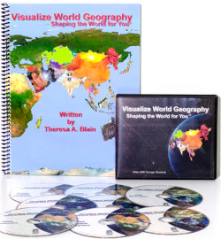
Visualize World Geography makes it easier for some students to learn geography through mnemonics presented through videos—visual images that help students make connections to the names of the countries. Because of the visual nature of the course, you can use it even with children who are not yet able to read independently. However, I would recommend it for those in third grade and above since they will benefit most from all elements of the program.
Visualize World Geography uses images or “pictographies” that include one or more neighboring countries. For example, Chile, Argentina, and Bolivia are grouped together to make an image of a chili pepper. The program presents the mnemonic, explaining that the country of Chile is an orange strip running down one side of the chili pepper. It continues, “Argentina is the red, fleshy part of our Chili Pepper. Ardent Tina lives in Argentina. The word ‘ardent’ means passionate; Tina is sure passionate about peppers! That is why Tina is known as ‘ardent’ Tina—because of her passion for chili peppers!” Bolivia, sitting at the top of both countries, is depicted as the leaves of the chili pepper: “When Tina plucks the leaves off the peppers so she can cook them, she places all the leaves in a bowl. It is the bowl of leaves we call Bowl-leaf-ia (Bolivia).” Students will become very familiar with puns in this curriculum! Sure, some of it is corny (purposely so), but for many students, mnemonics really do help them remember and visualize much better.
You can purchase a physical set of eight DVDs and a workbook, or you can subscribe (two years of access per subscription) to the online program that includes printable pages from the book along with access to the videos. Four of the DVDs present the mnemonics videos—one for each geographical region. The other four DVDs, titled Physical Geography, present other photos, maps, film footage, and interesting information about each country. Some "skit" videos in the online version teach within a context, such as newscasting or a Star Trek theme, getting to the mnemonics in a more roundabout fashion. Each video presentation is relatively brief. Online, the different types of videos are clearly presented as four options for each group of countries in each lesson: Facts, Direct, INS, and Skit. The Facts videos teach the physical geography of each country, while the other three present the mnemonics for each country in a variety of ways. Students usually begin with the “Direct” mnemonic videos, and add the INS videos if they want to learn the capital cities. Skit videos are optional, but I think students might enjoy them the most.
Both the mnemonics and the study of geography are divided into four regions: South America, Africa, Asia, and the Americas. Oceania is added as a bonus lesson, grouped with the Americas. Online this is clearly laid out with 20 lessons each for the four areas, plus the bonus lesson—81 lessons in all. The continents can be studied out of order, but students should master one continent before moving on to another.
Coordinating with the videos, the Visualize World Geography workbook shows an outline map of a continent, then focuses in more closely on groups of countries to be studied on that continent. Within each continent, there are generally several countries grouped together to form an image or “pictography,” giving each country its own mnemonic. Students will generally use the workbook pages for review after watching the videos. Note that the student workbook is reproducible for use within your immediate family or group class.
At the back of the student workbook just before the index are ten Atlas Exercises, and these are also included in the online program. Students will likely need to refer to an atlas to answer many of these questions. The exercises also reinforce what students have learned through the other lessons in the program.
Both in the workbook and online, quizzes that ask students to identify the countries within each mnemonic group are provided for all four regions. There are also detailed questions for each lesson that quiz students on the information presented in the various videos, such as the capital of a country, the largest port in that country, or a historical event. You might have students read through these questions before they watch the videos since they will have to watch and listen carefully for information about the geography, climate, rivers, capital, important features, and other facts.
Generally, students should complete one lesson at a time, watching all the videos for the group of countries (or a single country sometimes) and completing the workbook pages.
The program also includes map-grid drawing pages that include continent outline maps formed with accurate latitude and longitude coordinates. If students use these and study the locations of continents and countries well, they should be able to draw a map of the entire world when they have completed the course.
The online program adds a project for each of the four regions with downloadable instructions, a graphic organizer, and suggested web resources.
Both the physical and online programs include answer keys. The book adds brief instructional information at the beginning. The workbook is not required if you subscribe to the online program, but it has a few additional resources and saves printing out many pages. So you can purchase a workbook to use with the online program if you wish.
Since this is really different than traditional programs, be sure to check out the sample video lesson on the publisher’s website.
Summary
Visualize World Geography is a unique way to learn that should work especially well for visual learners and those who find mnemonics helpful. I found the online program more convenient to use and easier to navigate, but owning the program rather than subscribing might work better for some families.


