
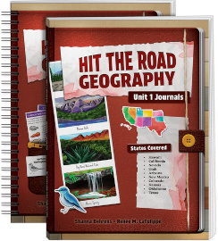
Hit the Road Geography teaches U.S geography for grades two through six. The entire, year-long course is presented in four separate units, each of which has two books subtitled Journals and Activities. Only Unit 1 is available thus far, and it covers Hawai’i, California, Nevada, Utah, Arizona, New Mexico, Colorado, Kansas, Oklahoma, and Texas. (Studies of other states are being completed at a rate of about two per month, so they will be ready before you need them.)
The course uses a storytelling approach, featuring Thaddeus the cat as a first-person narrator, sharing his travel adventures in Journals. You can read from Journals, and you can also listen to professionally performed audiobook narrations for each state in Journals (free online to course purchasers).
Shanna Behrens, one of the course’s authors, also created the illustrations of points of interest, wildlife, plants, trees, cartoon characters, maps, and more. The full-color illustrations are great, but I would prefer actual photos of geographic points of interest, like the Flatirons in Boulder Colorado and Arches National Park in Utah.
Journals is not consumable, but Activities is since many of its pages are to be written on or cut apart.
Depending on your setting, you might need multiple copies of Journals as all children will need to see the pages, whether reading it to themselves or listening as it is read aloud.
Books are available in both print and digital formats, but the digital books are sold only as a unit bundle. However, you can purchase digital versions for one state at a time (only those in Unit 1 thus far) that include both Journals and Activities pages.
Other publishers’ studies of the states are generally presented within one book, so Hit the Road Geography’s four-book course means there’s much more on each state than we typically find in U.S. geography courses up through sixth grade. In addition, Activities enhances the study with academic work and fun activities.
How It Works
Lessons are clearly delineated for each day in both books, with either three or four days allotted per state. Every lesson uses a reading from Journals and pages from Activities, the latter always including both a Reflections page and one or more pages for an activity.
Journals
Thaddeus the cat’s journal entries have words highlighted in green, blue, and yellow. Green words identify land features; blue is used for bodies of water and coastline locations; and yellow points out vocabulary words students should learn, which are also presented on a glossary sheet that introduces each state.
The journal entries are written the way a person might actually write them, such as the beginning of this entry on page 16:
11:00 a.m. – That was AMAZING!!!!!! Crabby and I went to Anini Beach on the north shore. The reef keeps the waters calm and clear, so it was easy for me to paddle around. And what a spectacular aquatic show!
This same day’s adventure has entertaining elements, like Thaddeus trying to get into a wetsuit, and then trying to dry off after snorkeling and falling asleep under a hood dryer. There’s an image of him looking like a pufferfish. Facts and fun are intertwined.
Lest the authors make Thaddeus sound too pedantic by trying to convey all the geographical information via journal entries, sidebars take on that task. They add geographical information, interesting features not mentioned by Thaddeus, small maps showing Thaddeus’s route, cultural insights, and occasional illustrations and bits of historical information. A State Recap at the end of each lesson summarizes Thaddeus’s experiences and also presents state facts in a chart (e.g., capital, bird, industries), accompanied by images of the state bird, tree, and flower.
Activities
First up in Activities are two pages with maps of the U.S., one to be used by students to track progress by coloring each state as they study it. (I would have older students add other locations on their maps, such as state capitals, major landmarks, or geographic features. (It’s not a large map, so this would be difficult for small states.)
One or more pages present the glossary of words and definitions. These include generic geographic terms like summit, peninsula, and tributary, along with words related to wildlife, and descriptive words (e.g., spectacular and vibrant). The glossary words appear within that state’s journal entries but are usually broadly applicable.
Each day’s Activities assignments begin with Reflections—discussion questions that involve both comprehension and listening skills, and one that asks children to relate their own thoughts. Reflections concludes with a writing assignment that is generally creative. For instance, some writing assignments have children write poems (with plenty of suggestions and direction), think of creative names for local items of interest (like geographic features named for their appearance, such as Mitten Butte, which is shaped like a mitten), complete Mad-Libs© type pages, come up with their own hyperboles, and write short, creative compositions.
The other activities (one per lesson) include worksheets, cut-and-paste pages, map work, puzzles, games, recipes, and even a science experiment. Lots of variety! Primarily using pages from the book, students create dioramas, games, booklets, and other projects that reinforce learning. Sometimes you need additional resources, especially for recipes like one for making sopapillas on page 103. Most resources should be readily available, but a few, like limestone, a seashell, and coral, might not be. However, those three items are optional—they’re marked with an asterisk on the materials list on page 10 of Journals. That same page also has a QR code and URL for downloading a coloring page for each state.
The lessons can be used in an open-and-go fashion most of the time. Many will take only 10 to 15 minutes a day, although some will take a bit longer. There are several ways you could fit it into your curriculum. For instance, you might be able to fit it in alongside a history course, spread it out over two or more years with less frequent lessons, or use a unit for summer school.
Summary
Hit the Road! Geography makes the study of geography feel like a road trip, and the colorful illustrations and variety of activities are likely to be kid-pleasing.